 skeechanAi Otsukaholic skeechanAi Otsukaholic
Premium Member
join:2012-01-26
AA169|170 |
to DanHo
Re: ios6 Maps is amazing!Maybe I didn't eat my Wheaties or should have studied more in school but it seems Apple should have just BOUGHT a company (or companies) with an app (or apps) that worked instead of buying a mapping firm and trying to build a GUI for it quickly and then getting it wrong or not finish in time. MS did it with Giant when they needed AV and it worked out great for them. |
|
| |
said by skeechan:Maybe I didn't eat my Wheaties or should have studied more in school but it seems Apple should have just BOUGHT a company (or companies) with an app (or apps) that worked instead of buying a mapping firm and trying to build a GUI for it quickly and then getting it wrong or not finish in time. MS did it with Giant when they needed AV and it worked out great for them. Or they could have delayed the new Apple Maps app, much like they did with Game Center and their Push Notification Service. |
|
 NezmoThe name's Bond. James Bond. NezmoThe name's Bond. James Bond.
MVM
join:2004-11-10
Coppell, TX |
to Metatron2008
I almost forgot about the free MapQuest app. Turn by turn, works great. I have used it many times when traveling for work. |
|
| |
to grunze510
said by grunze510:Or they could have delayed the new Apple Maps app, much like they did with Game Center and their Push Notification Service.
The contract with Google expired, so it was either release what they have now or not have a Maps app. Nobody really knows the details of the contract renewal, but my guess is it was mutual. |
|
| |
said by Thinkdiff:... The contract with Google expired, so it was either release what they have now or not have a Maps app. Nobody really knows the details of the contract renewal, but my guess is it was mutual.
...plus, I don't think anyone could have anticipated (when they first agreed to the deal) the potential of a mapping app. Maybe in 200? when Apple and Google agreed, the expectation was it would be a nice feature and just that... but now, presumably, it is viewed as a golden goose. So, either Google asked too much ... or Apple figured they'd be better off controlling the app (and the revenue). In any event, it's done, so we'll all have to wait a few months for them to work out the kinks. |
|
 Michail Michail
Premium Member
join:2000-08-02
Boynton Beach, FL |
to skeechan
said by skeechan:You aren't the first to mention Waze, when I get home I'm definitely taking a look.
I just tried it out -- really a cool app. I wonder if it's the data collection they are going after for their business model? We are like geo data collection bots for them. I've also been thinking about the Garmin app. I like the design of their software and interfaces. The only downside is the price. However, it's the same as purchasing an updated map from them. |
|
| |
to Metatron2008
No one is perfect...I just did Google Maps from Bloomington Indiana to Schenectady NY and (out of boredom) clicked walking and see that they expect you to walk across Lake Erie » maps.google.com/maps?sad ··· &t=m&z=6Either the lake is so polluted that this is possible or maybe Google Maps thinks I'm the messiah. So, I guess we can cut Apple a little slack |
|
|
skeechanAi Otsukaholic
Premium Member
join:2012-01-26
AA169|170 |
skeechan
Premium Member
2012-Sep-21 3:23 pm
That is a ferry across the lake.
142. Take the Pelee Island, ON - Sandusky, OH ferry to Sandusky
Entering United States (Ohio) |
|
 AVDRespice, Adspice, Prospice AVDRespice, Adspice, Prospice
Premium Member
join:2003-02-06
Onion, NJ |
to Michail
said by Michail:said by skeechan:You aren't the first to mention Waze, when I get home I'm definitely taking a look.
I just tried it out -- really a cool app. I wonder if it's the data collection they are going after for their business model? We are like geo data collection bots for them. I've also been thinking about the Garmin app. I like the design of their software and interfaces. The only downside is the price. However, it's the same as purchasing an updated map from them. its an open source effort, I don't think there is a business model per say. |
|
| |
to skeechan
said by skeechan:That is a ferry across the lake.
142. Take the Pelee Island, ON - Sandusky, OH ferry to Sandusky
Entering United States (Ohio)
oops! missed that one...but if you're going to take a ferry, might as well take a bus, airplane or car, too, no? |
|
skeechanAi Otsukaholic
Premium Member
join:2012-01-26
AA169|170 |
skeechan
Premium Member
2012-Sep-21 3:41 pm
People like the ferry, better experience being on the water than in a bus. |
|
 burner50Proud Union THUG burner50Proud Union THUG
Premium Member
join:2002-06-05
Iowa |
to haroldo
said by haroldo:Yuuuup!
But it's only as good as the person who enters it, so if a guy takes a minute to report it, the location will be placed at the location at the time of entry, rather than the actual location, so YMMV...plus police cars move, so they might be in one location at time of report, but another by the time you get there. The system asks for confirmation from other wazers that the item, (traffic, construction, police, etc.) is still there...so it can remove items no longer valid.
Red light cameras, too!
I've noticed on the Android version, once I hit the "hazard" button, no matter how long I take to enter it, it always places the pop up at the location I first pressed the button. |
|
 darciliciousCyber Librarian darciliciousCyber Librarian
Premium Member
join:2001-01-02
Forest Grove, OR ·Ziply Fiber ·Ziply Fiber
|
to haroldo
said by haroldo:said by skeechan:That is a ferry across the lake.
142. Take the Pelee Island, ON - Sandusky, OH ferry to Sandusky
Entering United States (Ohio)
oops! missed that one...but if you're going to take a ferry, might as well take a bus, airplane or car, too, no? ?? Taking a ferry doesn't mean you are in a bus, car, or plane. If you're on foot you can swim (what map software would advise a user to do THAT?) or take a ferry. If you're on a bus or in a car, I'm sure ferry shows up as well. If you're in an airplane what are you doing using maps to begin with?  |
|
| |
to burner50
said by burner50:...
I've noticed on the Android version, once I hit the "hazard" button, no matter how long I take to enter it, it always places the pop up at the location I first pressed the button.
Probably the same, but at 60 MPH by the time you (or hopefully the passenger) gets to the screen to press the button, you could be a mile away, or more. |
|
burner50Proud Union THUG
Premium Member
join:2002-06-05
Iowa |
burner50
Premium Member
2012-Sep-21 5:09 pm
said by haroldo:said by burner50:...
I've noticed on the Android version, once I hit the "hazard" button, no matter how long I take to enter it, it always places the pop up at the location I first pressed the button.
Probably the same, but at 60 MPH by the time you (or hopefully the passenger) gets to the screen to press the button, you could be a mile away, or more. I have my phone (Samsung Epic Touch 4G) in the Samsung Dock on my windshield... I let waze run in the foreground... I can usually hit the button just the same time I pass the hazard / police / etc... In my experience, the locations of Cars stopped on the side of the road are accurate to ~100 feet or so... |
|
skeechanAi Otsukaholic
Premium Member
join:2012-01-26
AA169|170 |
skeechan
Premium Member
2012-Sep-21 5:17 pm
For me, the California Highway Patrol always parks in the same few spots, so I could be ready for them if it works like it looks to (I haven't actually added any alerts, I'm just toying with the app in my office). Wow, there are tons of users around me. |
|
burner50Proud Union THUG
Premium Member
join:2002-06-05
Iowa |
burner50
Premium Member
2012-Sep-21 5:21 pm
said by skeechan:For me, the California Highway Patrol always parks in the same few spots, so I could be ready for them if it works like it looks to (I haven't actually added any alerts, I'm just toying with the app in my office). Wow, there are tons of users around me.
The one thing to look out for: It shows the icons for things in the map, but it doesn't actually alert you unless you're using Navigation and your route takes you along that path. |
|
skeechanAi Otsukaholic
Premium Member
join:2012-01-26
AA169|170 |
skeechan
Premium Member
2012-Sep-21 5:24 pm
That's fine, my commute is about 30 minutes long so I'd just check it as I'm walking out the door. I added my favorite destinations and it looks dead on accurate. This is way cool. I like that it can learn routes because I take a particular short cut to the freeway that none of these apps ever use. |
|
| |
If it's not accurate, there's a bull dozer icon you click to pave a new road. |
|
skeechanAi Otsukaholic
Premium Member
join:2012-01-26
AA169|170 |
skeechan
Premium Member
2012-Sep-21 5:35 pm
It shows the roads but doesn't know those intersections are horribly and the traffic lights long. Cutting through a side street shortcut is way faster (and goes by a Costco that has cheap gas). But technically it's a long cut...only shorter in time. |
|
 DanHo DanHo
Premium Member
join:2002-05-20
Seattle, WA |
to skeechan
said by skeechan: I like that it can learn routes because I take a particular short cut to the freeway that none of these apps ever use.
I find that function lacking. It always want me to go a certain way to the freeway, but it takes longer (time wise) to go that way. I've been using Waze for over a year now and it still hasn't figured it out. |
|
burner50Proud Union THUG
Premium Member
join:2002-06-05
Iowa |
to Metatron2008
I've been in moderate traffic before and it has popped up to ask me if I am in traffic.
Once I clicked yes, it started tracking where I slowed down and showed slow traffic where I was. |
|
| |
I'm not sure if it asks if you're in traffic because it knows you're going slowly...or if someone else reported traffic and the system wanted to confirm it. |
|
 owlyn owlyn
MVM
join:2004-06-05
Newtown, PA |
owlyn
MVM
2012-Sep-21 6:57 pm
I probably confused the hell out of it on my way home tonight. I take the train. |
|
skeechanAi Otsukaholic
Premium Member
join:2012-01-26
AA169|170 |
to burner50
It nailed my 25 mile commute within TWO MINUTES. Pretty damn amazing. |
|
| |
to haroldo

Historic photo, New Apple map |
said by haroldo:If it's not accurate, there's a bull dozer icon you click to pave a new road.
Can I use that dozer to erase a road? The road with the cars on it but without the road lines hasn't existed since mid 2010 when Newport road opened to the public. I moved here August 2010 and rode the new road then. And yes I got this photo today. |
|
burner50Proud Union THUG
Premium Member
join:2002-06-05
Iowa |
to haroldo
said by haroldo:I'm not sure if it asks if you're in traffic because it knows you're going slowly...or if someone else reported traffic and the system wanted to confirm it.
It specifically stated that it noted that my speed had been low for some distance and asked if I was in traffic. |
|
| |
to Metatron2008
A picture, or in this case multiple pictures are worth 10,000 words which just so happens to be about how many posts one poster made in this thread alone. LOL! (We'll disregard the little fact that 90 percent of his posts just repeated themselves.) Is there a post equivalent of an autopen now?  |
|
| |
to skeechan
my test with maps will be in a few weeks when I go down to OBX. So far it has been great locally.
Just ignore Alcohol, he is the same person that said Apple needs to have a removable battery and that having a removable battery doesn't take anymore space than one built in. He knows everything. He posted this about 3 years ago |
|
 Metatron2008You're it Metatron2008You're it
Premium Member
join:2008-09-02
united state |
Here's a few new funny faves: 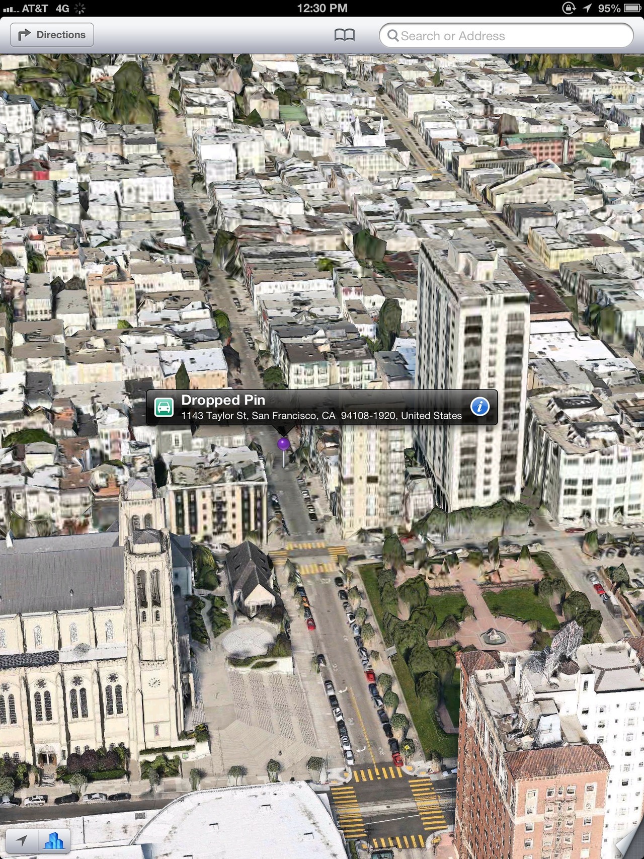 San Fran after an earthquake. 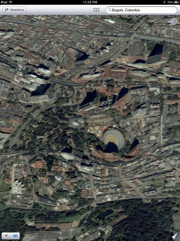 wtf? |
|


