| |
to 54067323
Re: power substation questionIn other words, it is a safety device? |
|
54067323 (banned)
join:2012-09-25
Tuscaloosa, AL
1 edit |
54067323 (banned)
Member
2013-May-5 8:00 am
said by Cho Baka:In other words, it is a safety device?
Yea, intrusion detection. But having found another photograph I can assure it is not. |
|
|
| 54067323 |
to Cho Baka
said by Cho Baka:In other words, it is a safety device?
Having found a much beter shot of the structure I can say for sure it is not an IDS, the dish is about 36" across, which is too large for an IDS system and pointing almost due west, as such that is IMO a point to point microwave dish with an elevation of about 20 feet. |
|
 Subaru1-3-2-4 Subaru1-3-2-4
Premium Member
join:2001-05-31
Greenwich, CT |
Subaru
Premium Member
2013-May-5 8:26 am
Yeah I've looked on the other far end and I can't figure out what it's aiming for since you have a lot of stuff in between with that elevation. |
|
54067323 (banned)
join:2012-09-25
Tuscaloosa, AL |
54067323 (banned)
Member
2013-May-5 8:27 am
said by Subaru:Yeah I've looked on the other far end and I can't figure out what it's aiming for since you have a lot of stuff in between with that elevation. Is that site on a hill? |
|
Subaru1-3-2-4
Premium Member
join:2001-05-31
Greenwich, CT |
Subaru
Premium Member
2013-May-5 8:30 am
nope not at all.. I take the road old trolly Ln to Witch Ln and the elevation starts to climb, and by that time it's already very wooded. |
|
54067323 (banned)
join:2012-09-25
Tuscaloosa, AL |
54067323 (banned)
Member
2013-May-5 8:41 am
said by Subaru:nope not at all.. I take the road old trolly Ln to Witch Ln and the elevation starts to climb, and by that time it's already very wooded. Then one would think the other end is not too far off, but keep in mind for an application like that (pump status on/off/hand and oil temp 4-20 ma) all they need is a 9.6k loop so they can get away with a bit more. Years back I worked on a C band point to point link that shot right through a forest, which one by looking at it would think no flipping way, but it worked and got the RADAR site on line pending a two year wait for permits allowing the local telco to bring a cable to the site. But again, we where only running two 9.6k links through it. |
|
Subaru1-3-2-4
Premium Member
join:2001-05-31
Greenwich, CT |
Subaru
Premium Member
2013-May-5 8:47 am
I would assume the receiving end would be about the same or have the same setup? My way to the highway almost follows the LOS but I've never seen this setup anyplace else, matter of fact I don't recall another area like this.. I thought I had an idea at first but it's a little further south. |
|
54067323 (banned)
join:2012-09-25
Tuscaloosa, AL |
54067323 (banned)
Member
2013-May-5 8:54 am
said by Subaru:I would assume the receiving end would be about the same or have the same setup? There may not be another end, the utility may have turned the system down years ago and the dish in the photograph was abandoned in place while the other end had to be removed due to a lease agreement. Utilities have a tendency to install more and more crap and unless the old equipment is in the way it is no ones job to remove it. Trust me, if I could legally harvest some of the equipment I have seen abandoned in place, I would have a whole lot more cash in my pocket. |
|
Subaru1-3-2-4
Premium Member
join:2001-05-31
Greenwich, CT |
Subaru
Premium Member
2013-May-5 9:35 am
said by 54067323:said by Subaru:I would assume the receiving end would be about the same or have the same setup? There may not be another end, the utility may have turned the system down years ago and the dish in the photograph was abandoned in place while the other end had to be removed due to a lease agreement. Utilities have a tendency to install more and more crap and unless the old equipment is in the way it is no ones job to remove it. Trust me, if I could legally harvest some of the equipment I have seen abandoned in place, I would have a whole lot more cash in my pocket. I like how they keep it so the over-growth does not cover the dish. It maybe very well shut down. |
|
54067323 (banned)
join:2012-09-25
Tuscaloosa, AL
1 recommendation |
54067323 (banned)
Member
2013-May-5 10:27 am
said by Subaru:I like how they keep it so the over-growth does not cover the dish. It maybe very well shut down.
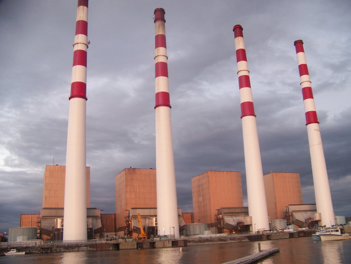
If it is still working, this may be the other end of it. » maps.google.com/maps?q=D ··· cut&z=15FWIW Northeast Utilities has numerous point to point 6.7 / 6.8 GHz microwave systems operating out of Woodward Avenue Norwalk Harbor generating station with an antenna height of 106.7 meters. |
|
Subaru1-3-2-4
Premium Member
join:2001-05-31
Greenwich, CT |
Subaru
Premium Member
2013-May-5 10:38 am
My eyes must be bad  where on the map? |
|
54067323 (banned)
join:2012-09-25
Tuscaloosa, AL
3 edits
1 recommendation |
54067323 (banned)
Member
2013-May-5 10:56 am
said by Subaru:My eyes must be bad where on the map? Your eyes are fine, I just forgot to place the other marker on the map, anyhow go SE about 8Kf from the “A” marker and you will see on a peninsula just south of Longshore Ave with three white tanks on it, that’s the generating station, my guess is the antennas are up on the stack. |
|
Subaru1-3-2-4
Premium Member
join:2001-05-31
Greenwich, CT |
Subaru
Premium Member
2013-May-5 11:02 am
said by 54067323:said by Subaru:My eyes must be bad where on the map? Your eyes are fine, I just forgot to place the other marker on the map, anyhow go SE about 8Kf from the “A” marker and you will see on a peninsula just south of Longshore Ave with three white tanks on it, that’s the generating station, my guess is the antennas are up on the stack. hmm wow I think you might be right.. look up on the smoke stack and you will see the antenna pointing towards that area.. that has me wondering maybe the receiving end is using the area across the street for a reflection? i'm not too sure why it's not faced the other way. » goo.gl/maps/BQQju |
|
54067323 (banned)
join:2012-09-25
Tuscaloosa, AL |
54067323 (banned)
Member
2013-May-5 11:09 am
said by Subaru:hmm wow I think you might be right.. look up on the smoke stack and you will see the antenna pointing towards that area.. that has me wondering maybe the receiving end is using the area across the street for a reflection? i'm not too sure why it's not faced the other way. Interesting, there is a passive repeater at 41-04-51.3 N, 073-25-52.4 W with a height of 20.1 meters. |
|
Subaru1-3-2-4
Premium Member
join:2001-05-31
Greenwich, CT |
Subaru
Premium Member
2013-May-5 11:33 am
lost me on that one  Are you talking about the large tower? |
|
54067323 (banned)
join:2012-09-25
Tuscaloosa, AL |
54067323 (banned)
Member
2013-May-5 12:10 pm
said by Subaru:lost me on that one
Are you talking about the large tower? Not sure where it can be found on GM, I was just going by the coordinates in the FCC database. 41-04-51.3 N, 073-25-52.4 W with a height of 20.1 meters. It is listed as a reflector 1.8 m high and 2.4 m wide located at the above latitude and longitude. |
|
|
Subaru1-3-2-4
Premium Member
join:2001-05-31
Greenwich, CT |
Subaru
Premium Member
2013-May-5 12:16 pm
said by 54067323:said by Subaru:lost me on that one
Are you talking about the large tower? Not sure where it can be found on GM, I was just going by the coordinates in the FCC database. 41-04-51.3 N, 073-25-52.4 W with a height of 20.1 meters. It is listed as a reflector 1.8 m high and 2.4 m wide located at the above latitude and longitude. In google earth it shows that coordinates as being here » goo.gl/maps/mzq0X |
|
54067323 (banned)
join:2012-09-25
Tuscaloosa, AL |
54067323 (banned)
Member
2013-May-5 12:37 pm
And there it is, another dish on the transmission tower pointing back at the one in question, from there they probably have it shot down their ROW back to the generating station. |
|
Subaru1-3-2-4
Premium Member
join:2001-05-31
Greenwich, CT |
Subaru
Premium Member
2013-May-5 12:41 pm
I was expecting it to look like the other, looks like the flat drum type |
|
54067323 (banned)
join:2012-09-25
Tuscaloosa, AL |
54067323 (banned)
Member
2013-May-5 6:13 pm
said by Subaru:I was expecting it to look like the other, looks like the flat drum type That very well could be a parabolic dish with a side shield, which would make sense if they are using it as part of a passive repeater. |
|
Subaru1-3-2-4
Premium Member
join:2001-05-31
Greenwich, CT |
Subaru
Premium Member
2013-May-5 6:28 pm
So in all it's just to monitor that end of the station? |
|
54067323 (banned)
join:2012-09-25
Tuscaloosa, AL |
54067323 (banned)
Member
2013-May-5 6:46 pm
said by Subaru:So in all it's just to monitor that end of the station? Yes based on the licensing it is a point to point, three path circuit back to the generating station. The callsign of the MLK location is WNTT422 and it connects to KCH91. Finally, I once I logged out of my FRN, I was able to get a workable link to the license database, for some reason when logged in the links where all pooched. None the less this is KCH91. » wireless2.fcc.gov/UlsApp ··· y=957592And this is WNTT422. » wireless2.fcc.gov/UlsApp ··· =1028669Or so I hope.  |
|
Subaru1-3-2-4
Premium Member
join:2001-05-31
Greenwich, CT |
Subaru
Premium Member
2013-May-5 6:53 pm
Wow I would of never found that!  So at least from what it seems they use 5 passive repeaters? |
|
54067323 (banned)
join:2012-09-25
Tuscaloosa, AL
2 edits |
54067323 (banned)
Member
2013-May-5 7:02 pm
said by Subaru:So at least from what it seems they use 5 passive repeaters? Not really, they have one shall we call a primary site KCH91 and from there there are links to other sites, only one of which involves a passive repeater. |
|
Subaru1-3-2-4
Premium Member
join:2001-05-31
Greenwich, CT |
Subaru
Premium Member
2013-May-5 7:46 pm
Ah I see Location 2 was not too hard to find » pics4.city-data.com/cpic ··· 1805.jpg man next time I go to the beach I'm going to notice the stacks now, I've never noticed them before given they are 600 Ft tall. Location 3 » www.panoramio.com/photo_ ··· =2094213location 4 Location that started this thread location 5 passive repeater near the tracks. » www.city-data.com/towers ··· cut.html |
|


